Your approach does not work with me dyno.
We will increase the distance to 55 kilometers, Hamilton - Toronto lakeshore west condominiums.
At that distance, there would be a 59 meter curvature, with an visual obstacle of 195 meters, given the position taken by the photographers right there on the beach (2 meters altitude).
http://www.flickr.com/photos/planetrick/487755017/Looking from the beach in Hamilton across Lake Ontario towards Toronto
 http://www.flickr.com/photos/planetrick/487726854/in/photostream/
Looking Across Lake Ontario at Toronto from Lake Ontario Beach in Hamilton
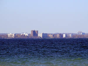
No curvature whatsoever, where there should have been 59 meters of it, given the 55 km distance, pictures taken right on the Hamilton Beach.
The authors of the photos right there on the beach, we do not need no magnification.
All the evidence is right here in the pictures dyno, do not pretend or play dumb, won't work with me.
Do you understand dyno?
The pictures were taken right on the Hamilton beach, so says the caption.
Those rocks there have about 1 meter in height, you have to be right there on the beach, to see those details, but I suppose you would like to increase the height to about 20 meters, wouldn't you?
No way Dyno, not with me here...
Your target does not specify the distance to the ships, that is what I am trying to tell you. The photos with the ships are worth nothing without a distance being offered, with proof.
As for the 18 km, you simply DID NOT USE A GOOD QUALITY CAMERA TO CAPTURE THE FULL DETAILS.